Within Disaster maps
AI flood maps
AI-assisted flood maps can reveal cut-off communities sooner, but radar limits and local verification still shape where aid goes first.
On this page
- How radar sees floods through cloud
- Why isolated communities are hard to find
- Where human checks still matter
Page outline Jump by section
Introduction
Floods create a brutal information problem. The roads that connect villages to nearby towns may disappear under water just as mobile networks fail and local authorities lose contact with residents. Emergency teams often know that flooding is severe, but not which communities are trapped, how many people are stranded, or which routes remain usable.
 AI-assisted flood maps are increasingly used to answer those questions faster. By combining radar satellites, machine-learning systems, and population data, responders can detect newly flooded areas within hours rather than waiting for full ground surveys. The practical value is not only seeing where water is, but identifying which settlements may now be isolated from hospitals, food deliveries, or evacuation routes. In the broader discussion about whether AI could help societies coordinate more effectively under stress, flood mapping is an important near-term example: machine intelligence helping humans build a shared operational picture during a crisis. Yet these systems also have limits. Radar images can be noisy, algorithms can mistake wet soil for floodwater, and local verification still matters when deciding where helicopters or rescue boats go first. [UNITAR]unitar.orgUNITARUNOSAT introduces AI in its flood rapid mapping…31 Aug 2020 — By using AI, satellite based analysis and related mapping are comp… [UN-SPIDER]un-spider.orgUN-SPIDERRecommended Practice: Radar-based Flood MappingThe UN-SPIDER Recommended Practice on radar-based flood mapping explains the use…
How radar sees floods through cloud
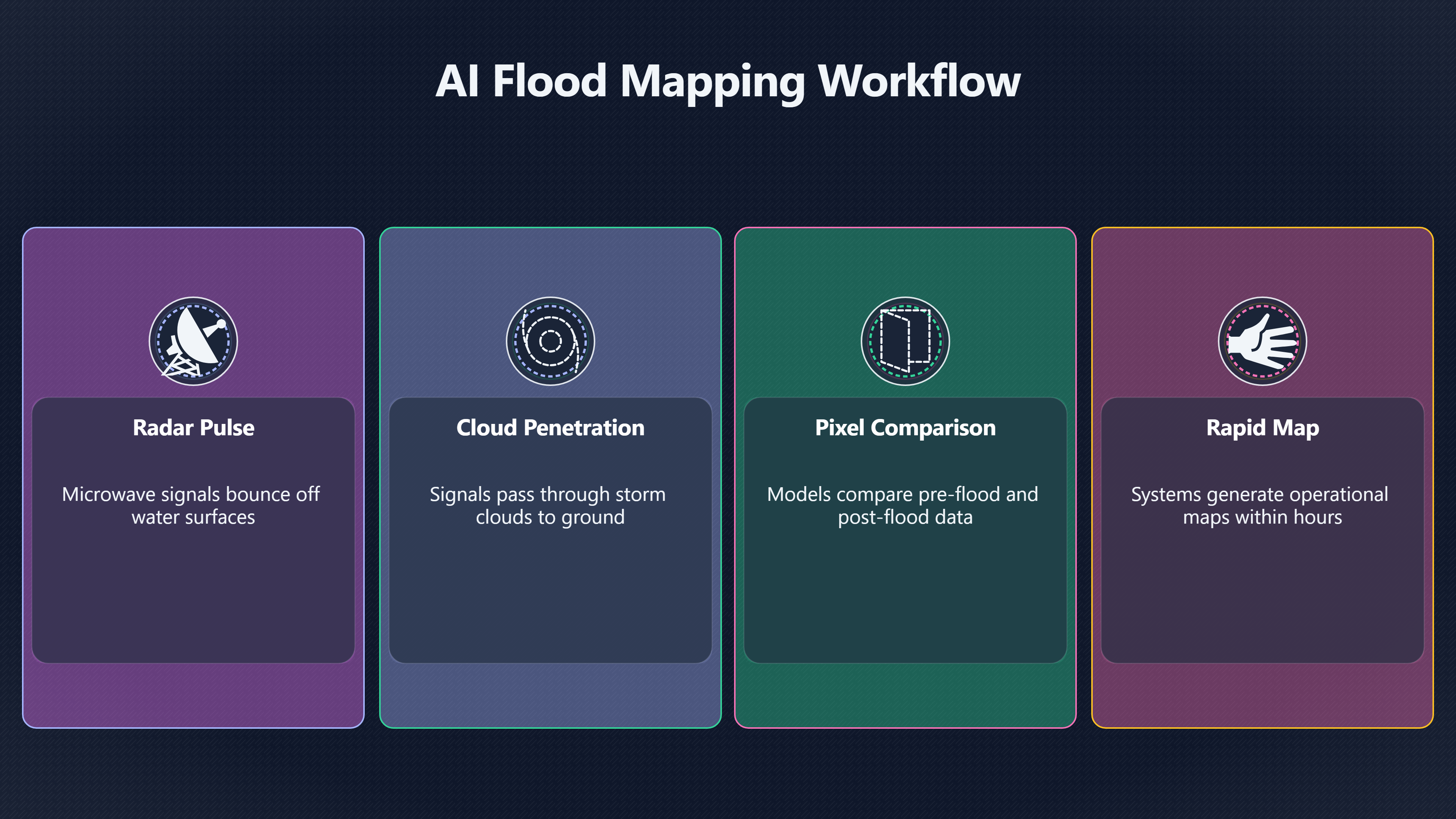
One reason AI flood mapping has become more useful in recent years is the growing use of synthetic aperture radar, usually shortened to SAR. Unlike ordinary optical satellites, radar satellites do not depend on daylight and can often see through thick cloud cover.
That matters because severe floods frequently arrive with storms that make normal satellite imagery nearly useless. Optical cameras may show nothing but cloud precisely when responders need information most urgently. Radar systems instead send microwave pulses toward the Earth and measure how the signals bounce back. Smooth floodwater reflects radar differently from dry ground, allowing computers to identify likely inundated areas even during ongoing storms. [UN-SPIDER]un-spider.orgUN-SPIDERRecommended Practice: Radar-based Flood MappingThe UN-SPIDER Recommended Practice on radar-based flood mapping explains the use… [CEMS Floods React]global-flood.emergency.copernicus.euCEMS Floods React Glo FAS Global Flood Monitoring (GFMCEMS Floods ReactGloFAS Global Flood Monitoring (GFM) - CopernicusThe new GFM provides a continuous monitoring of floods worldwide by imm…
AI systems accelerate this process by automating the interpretation. Instead of analysts manually outlining flooded zones image by image, machine-learning models compare pre-flood and post-flood radar data and identify pixels that likely changed from land to water. Modern systems can process huge areas quickly enough to support near-real-time emergency mapping. UNOSAT, the United Nations Satellite Centre, has increasingly used machine-learning-assisted workflows to speed up flood rapid mapping operations. [UNITAR]unitar.orgUNITARUNOSAT introduces AI in its flood rapid mapping…31 Aug 2020 — By using AI, satellite based analysis and related mapping are comp… [UNOSAT The speed gain matters operationally. A delayed map may mean helicopters are sent to the wrong district]unosat.orgSatellite detected water extents as of 5 January 2026…7 Jan 2026 — This map illustrates the flood extent derived from Sentinel-1 image…, fuel convoys take unusable roads, or evacuation centres are opened too late. Research on SAR-based flood mapping increasingly focuses on emergency response specifically because responders need actionable information while floods are still evolving, not days later for insurance or reconstruction analysis. [ScienceDirect]sciencedirect.comScienceDirectEvaluation of open-source SAR-based flood datasets for…by IK San Jose · 2025 · Cited by 1 — Flood extent maps are crucial… [PMC]pmc.ncbi.nlm.nih.govPMCA satellite imagery-driven framework for rapid resourcePMCby J Eudaric · 2024 · Cited by 9 — We propose a novel resource allocation framework based on remote sensing and geospatial data near t…
Recent systems also combine several data streams at once:
- Radar satellite imagery showing likely flood extent [un-spider.org]un-spider.orgUN-SPIDERRecommended Practice: Radar-based Flood MappingThe UN-SPIDER Recommended Practice on radar-based flood mapping explains the use…
- Optical imagery when clouds clear
- Elevation maps indicating where water is likely to flow
- Road and bridge networks
- Population estimates and settlement databases
- Historical flood patterns
This layered approach helps responders move from “where is water?” to “which communities may now be cut off?” That second question is usually harder and more important.
Why isolated communities are hard to find
Finding stranded communities is not simply a matter of locating flooded land. Many places flood without becoming fully isolated, while other communities may lose their only road connection after a relatively small breach or bridge collapse.
Rural isolation is especially difficult to detect quickly because official infrastructure maps are often incomplete. Informal roads, seasonal crossings, or small settlements may not appear clearly in government databases. During major floods, communications failures also remove the fastest source of information: direct reports from residents.
AI mapping systems try to infer isolation by combining flood extent with transport networks. If the only connecting road to a settlement appears submerged, or if all nearby bridges are likely underwater, the system can flag the area as potentially cut off. Some frameworks also combine satellite data with population estimates to prioritise locations where many people may be trapped. PMC [CEMS Floods React]global-flood.emergency.copernicus.euCEMS Floods React Glo FAS Global Flood Monitoring (GFMCEMS Floods ReactGloFAS Global Flood Monitoring (GFM) - CopernicusThe new GFM provides a continuous monitoring of floods worldwide by imm…
This becomes particularly valuable at scale. Large floods may affect thousands of square kilometres across several regions simultaneously. Human analysts cannot manually inspect every road corridor fast enough during the first critical hours. Machine-learning systems can instead scan for likely choke points and generate ranked alerts for emergency coordinators.
Several recent research efforts aim to improve these capabilities using multi-temporal data, meaning sequences of images collected before, during, and after floods. Instead of relying on a single snapshot, the models track how water spreads over time and compare current conditions against historical patterns. Studies evaluating SAR flood datasets for emergency settings found that multi-temporal inputs often improve flood detection accuracy substantially. [ScienceDirect]sciencedirect.comScienceDirectEvaluation of open-source SAR-based flood datasets for…by IK San Jose · 2025 · Cited by 1 — Flood extent maps are crucial…
The broader humanitarian significance is easy to underestimate. In many flood disasters, the deadliest period is not always the initial inundation but the following days, when isolated populations cannot access medicine, clean water, insulin, fuel, or emergency transport. Faster identification of cut-off areas can therefore change not only rescue logistics but survival rates.

Why AI mapping changes emergency timing
The most important effect of AI flood maps is often not precision but timing.
Traditional disaster mapping could require teams of specialists to manually process imagery, outline flood boundaries, and cross-reference transport infrastructure. AI-assisted systems reduce the delay between image capture and operational use. UNOSAT reported that AI-supported flood mapping substantially reduced processing time and automated much of the workflow. [UNITAR]unitar.orgUNITARUNOSAT introduces AI in its flood rapid mapping…31 Aug 2020 — By using AI, satellite based analysis and related mapping are comp…
That acceleration affects emergency decisions in several ways:
- Rescue teams can prioritise areas likely to be unreachable by road
- Air assets can be directed earlier toward isolated settlements
- Authorities can estimate where food shortages may emerge first
- Medical supply chains can reroute before roads fully fail
- Evacuation warnings can target communities at highest isolation risk
The difference between receiving this information in six hours rather than thirty-six can be decisive in fast-moving floods.
Some newer systems aim for continuous monitoring rather than isolated map releases. Research frameworks in South Asia, for example, combine multiple satellite systems so that when one source is unavailable because of cloud cover or timing gaps, another sensor can maintain near-real-time flood tracking. [arXiv]arxiv.orgSource details in endnotes.
This points toward a broader AI coordination capability. Disaster response is partly an intelligence problem: many actors possess fragmented information, but nobody initially sees the whole picture. AI-assisted mapping helps compress scattered signals into a common operational view that governments, aid agencies, and local responders can use simultaneously.
In the larger “AI bloom” debate, this is one concrete example of how machine intelligence could improve civilisational coordination rather than merely automate office work. The optimistic argument is not simply that AI makes mapping faster, but that increasingly capable systems may help societies respond to crises with greater collective awareness and lower informational friction.
Where human checks still matter
Despite the progress, AI flood maps remain far from fully reliable on their own.
Radar imagery has important limitations. Urban areas can create confusing reflections from buildings and metal structures. Dense vegetation may hide floodwater beneath tree cover. Wet soil can sometimes resemble shallow flooding. Temporary shadows or sensor noise may generate false positives. Researchers working on flood segmentation repeatedly note that model performance depends heavily on training data quality and regional conditions. [ScienceDirect]sciencedirect.comScienceDirectEvaluation of open-source SAR-based flood datasets for…by IK San Jose · 2025 · Cited by 1 — Flood extent maps are crucial…
This means a machine-generated flood layer is not automatically a trustworthy rescue map.
Human analysts still perform several essential checks:
- Comparing AI outputs with local reports
- Verifying whether roads are actually passable
- Checking whether settlements shown as isolated still have boat access
- Distinguishing seasonal water from disaster flooding
- Assessing whether vulnerable populations are present
In practice, many humanitarian systems treat AI as a triage tool rather than a final authority. The software rapidly identifies likely high-priority areas, while experienced emergency managers decide where to deploy scarce resources first.
There are also political and infrastructure limits that technology alone cannot solve. Some regions lack up-to-date settlement data. Some governments restrict data sharing during disasters. Remote communities may not appear clearly in mapping systems at all. AI can accelerate interpretation of available information, but it cannot fully compensate for absent infrastructure or weak institutions.
The distribution question matters too. Advanced flood-mapping systems depend on satellites, cloud computing, labelled training data, and technical expertise that poorer regions may lack. If access to these tools remains concentrated in wealthy governments or large international agencies, the benefits of faster coordination may diffuse unevenly.

What flood mapping suggests about AI and human flourishing
AI flood maps are a modest technology compared with grand claims about superintelligence or post-scarcity futures. They do not eliminate floods, repair infrastructure automatically, or remove the political difficulties of disaster response.
Yet they matter because they show a practical version of a larger possibility: machine intelligence helping humans understand rapidly changing situations faster than manual coordination alone allows.
Flood disasters compress time. Decisions that normally unfold over weeks must happen within hours. In that environment, better collective awareness becomes directly life-saving. AI-assisted mapping demonstrates one narrow but real example of how advanced computational systems may help societies process complexity under pressure.
The broader optimistic case around AI bloom extends far beyond emergency response. Advocates imagine AI systems accelerating medicine, science, energy, education, and governance across decades or centuries. Flood mapping does not prove those larger hopes. But it does provide evidence that machine intelligence can already augment human coordination in situations where incomplete information previously caused avoidable suffering.
The important caveat is that capability alone is not enough. The quality of outcomes still depends on institutions, local trust, infrastructure, transparency, and human judgement. Faster maps only help if governments and aid agencies can act on them fairly and effectively.
That tension runs through much of the wider debate about AI and humanity’s long-term future. The technology may expand what societies are capable of seeing and doing. Whether those gains become broadly shared improvements in human flourishing remains a political and institutional question as much as a technical one.
Endnotes
-
Source: unitar.org
Link: https://unitar.org/about/news-stories/news/unosat-introduces-ai-its-flood-rapid-mapping-operations-benefit-national-disaster-managementSource snippet
UNITARUNOSAT introduces AI in its flood rapid mapping...31 Aug 2020 — By using AI, satellite based analysis and related mapping are comp...
-
Source: un-spider.org
Link: https://www.un-spider.org/advisory-support/recommended-practices/recommended-practice-radar-based-flood-mappingSource snippet
UN-SPIDERRecommended Practice: Radar-based Flood MappingThe UN-SPIDER Recommended Practice on radar-based flood mapping explains the use...
-
Source: unosat.org
Link: https://unosat.org/products/4229Source snippet
Satellite detected water extents as of 5 January 2026...7 Jan 2026 — This map illustrates the flood extent derived from Sentinel-1 image...
Published: January 2026
-
Source: unosat.org
Link: https://unosat.org/products/3992Source snippet
ProductThis map illustrates aggregated satellite detected floods using Sentinel-1 images... Analysis: United Nations Satellite Centre (U...
-
Source: sciencedirect.com
Link: https://www.sciencedirect.com/science/article/pii/S2590061725001048Source snippet
ScienceDirectEvaluation of open-source SAR-based flood datasets for...by IK San Jose · 2025 · Cited by 1 — Flood extent maps are crucial...
-
Source: arxiv.org
Link: https://arxiv.org/abs/2605.10950 -
Source: sciencedirect.com
Link: https://www.sciencedirect.com/science/article/pii/S003442572500286XSource snippet
ScienceDirectUnderstanding flood detection models across Sentinel-1...by E Portalés-Julià · 2025 · Cited by 8 — In recent years, researc...
-
Source: arxiv.org
Link: https://arxiv.org/abs/2504.02214 -
Source: unosat.org
Link: https://unosat.org/products/3954Source snippet
Product8 Sept 2024 — This map illustrates the aggregated floods using Sentinel-1 images acquired between 18 to 26 August 2024 and between...
Published: August 2024
-
Source: unosat.org
Link: https://unosat.org/products/4228Source snippet
Satellite detected water extents as of 31 December 2025 in...2 Jan 2026 — This map illustrates the flood extent derived from Sentinel-1...
Published: December 2025
-
Source: global-flood.emergency.copernicus.eu
Title: CEMS Floods React Glo FAS Global Flood Monitoring (GFM)
Link: https://global-flood.emergency.copernicus.eu/react/technical-information/glofas-gfm/Source snippet
CEMS Floods ReactGloFAS Global Flood Monitoring (GFM) - CopernicusThe new GFM provides a continuous monitoring of floods worldwide by imm...
-
Source: github.com
Link: https://github.com/UNITAR-UNOSAT/UNOSAT-AI-Based-Rapid-Mapping-ServiceSource snippet
UNITAR-UNOSAT/UNOSAT-AI-Based-Rapid-Mapping-...The UNOSAT Flood Dataset has been created for this study using Copernicus Sentinel-1 sate...
Additional References
-
Source: nasa.gov
Link: https://www.nasa.gov/Source snippet
NASANational Aeronautics and Space Administration. NASA explores the unknown in air and space, innovates for the benefit of humanity, and...
-
Source: x.com
Link: https://x.com/NASA?lang=enSource snippet
NASA (@NASA) / Posts / XAfter reviewing the @Space_Station flight schedule, @NASA and its partners are adjusting launch opportunities for...
-
Source: instagram.com
Link: https://www.instagram.com/nasa/?hl=enSource snippet
NASA (@nasa) • Instagram photos and videosAll four Artemis II astronauts are out of Orion Integrity and safely aboard recovery boats in t...
-
Source: pure.ed.ac.uk
Link: https://www.pure.ed.ac.uk/ws/files/241290517/Towards_global_MATEO_GARCIA_DOA04032021_VOR_CC_BY.pdfSource snippet
global flood mapping onboard low cost satellites with...by G Mateo‑Garcia · Cited by 268 — Spaceborne Earth observation is a key technol...
-
Source: pmc.ncbi.nlm.nih.gov
Title: PMCA satellite imagery-driven framework for rapid resource
Link: https://pmc.ncbi.nlm.nih.gov/articles/PMC11336247/Source snippet
PMCby J Eudaric · 2024 · Cited by 9 — We propose a novel resource allocation framework based on remote sensing and geospatial data near t...
-
Source: [microsoft]({{ ‘ai-bloom-abun/ai-bloom-abun-98d3a6-shared-ai-gai-89312d-ai-platform-l-e1f9a1-microsoft-ope-846027/’ | relative_url }}). com
Title: mapping global floods with 10 years of satellite radar data
Link: https://www.microsoft.com/en-us/research/publication/mapping-global-floods-with-10-years-of-satellite-radar-data/Source snippet
1 Jul 2025 — We create a unique, longitudinal global flood extent dataset with predictions unaffected by cloud coverage, offering compreh...
-
Source: medium.com
Link: https://medium.com/un-global-pulse/fusing-ai-into-satellite-image-analysis-to-inform-rapid-response-to-floods-23287cdf7ffbSource snippet
mapping flooded areas which currently exists in PulseSatellite.Read more...
-
Source: home.cern
Title: unosat cern satellite mapping good humanity
Link: https://home.cern/news/news/knowledge-sharing/unosat-cern-satellite-mapping-good-humanitySource snippet
UNOSAT at CERN: Satellite mapping for the good of...5 Jul 2021 — UNOSAT has partnered with CERN as part of the CERN openlab collaboratio...
-
Source: learn.arcgis.com
Title: map floods with sar data and deep learning
Link: https://learn.arcgis.com/en/projects/map-floods-with-sar-data-and-deep-learning/Source snippet
floods with SAR data and deep learning | DocumentationUse a deep learning pretrained model to extract water pixels from pre- and post-flo...
-
Source: cbsnews.com
Title: ufo files apollo 17 crew mysterious objects 1972 mission
Link: https://www.cbsnews.com/news/ufo-files-apollo-17-crew-mysterious-objects-1972-mission/Source snippet
UFO files reveal Apollo 17 crew saw mysterious objects, lights during 1972 mission: "Looks like the Fourth of July"...
Amazon book picks
Further Reading
Books and field guides related to AI flood maps. Use these as the next step if you want deeper reading beyond the article.
Flood Risk Management : Research and Practice
First published 2008. Subjects: Floods, Flood control, Europe, environmental conditions, Congresses, Risk assessment.

Integrated Flood Risk Management
First published 2022. Subjects: Flood damage prevention, Flood control, Risk management, Emergency management, International cooperation.
Disaster response and recovery
First published 2007. Subjects: Disaster relief, SOCIAL SCIENCE / Sociology / General, Emergency management.
Case Studies In Disaster Response And Emergency Management
First published 2013. Subjects: Emergency management, Case studies, POLITICAL SCIENCE / Public Policy / City Planning & Urban Development...
eBay marketplace picks
Marketplace Samples
Example marketplace items related to this page. Use the search link to explore similar finds on eBay.

Example eBay listing
A.I. Artificial Intelligence Original Movie Poster Signed By Jude Law
USD 125.00 | Shipping USD 25.00 | US

Example eBay listing
Artificial Intelligence D/S Original Movie Poster - 27 x 40"
USD 19.50 | Shipping USD 13.65 | US

Example eBay listing
612388 Artificial Intelligence Movie Science Fiction Drama Wall Print Poster
USD 22.95 | Shipping USD 12.95 | JP

Example eBay listing
Companion - Artificial Intelligence Dark Comedy Cinema Film - POSTER 20"x30"
USD 23.99 | Free shipping | US

Example eBay listing
A.I. Artificial Intelligence Movie Film Poster Art Print
GBP 4.99 | Free shipping | GB

Example eBay listing
A.I. - Artificial Intelligence Movie/Film Poster Art PICTURE / PRINT 9" x 8"
GBP 2.49 | Shipping GBP 1.75 | GB

Example eBay listing
A I Artificial Intelligence 6 Movie Poster Art Print Print Classic Rare Gallery
GBP 49.00 | Free shipping | GB

Example eBay listing
Artificial Intelligence Framed Wall Art Poster Canvas Print Picture
GBP 8.99 | Shipping GBP 4.99 | GB
Topic Tree