Within Coordination
AI disaster maps
AI damage maps can shorten the gap between a disaster happening and help reaching the places hit hardest.
On this page
- How computer vision turns imagery into an emergency map
- Why human analysts still decide what the map means
- Where faster damage assessment can fail in real disasters
Page outline Jump by section
Introduction
When a hurricane, earthquake, wildfire, or flood hits, one of the hardest problems is simply understanding what has happened quickly enough to respond well. Roads may be blocked, communications disrupted, and eyewitness reports incomplete. In many disasters, aid agencies spend crucial hours or days building a picture of where the damage is worst before they can confidently direct rescue teams, medical supplies, food, or temporary shelter.
 AI-assisted disaster maps aim to shorten that gap. By combining satellite imagery, drone footage, radar data, and computer vision systems that can detect damaged buildings or flooded land, emergency teams can often identify heavily affected areas far faster than manual analysis alone. The core promise is not that AI replaces emergency managers, but that it helps humans coordinate under pressure by turning huge volumes of imagery into a usable operational map. In the broader debate about whether AI can help civilisation coordinate better, disaster mapping is one of the clearest near-term examples where machine intelligence may improve collective response capacity in ways that save lives. [ScienceDirect]sciencedirect.comScienceDirectComputer vision tools for early post-disaster assessmentby R Soleimani · 2024 · Cited by 21 — Remote sensing data, particula… [Department of Homeland Security]dhs.govDepartment of Homeland SecurityFederal Emergency Management Agency – AI Use Cases16 Dec 2024 — RGO reviews satellite, aerial, and radar i…
How computer vision turns imagery into an emergency map
Modern disasters generate enormous amounts of visual data. Satellites continuously image the Earth. Drones flown by emergency crews capture close-up views of damaged neighbourhoods. Aircraft equipped with radar can scan flood zones even through cloud cover. The challenge is that humans cannot rapidly inspect all of this material during a fast-moving emergency.
Computer vision systems are increasingly used to automate the first pass. These systems compare images from before and after a disaster and search for visible changes associated with destruction: collapsed roofs, washed-out roads, standing water, debris fields, scorched vegetation, or damaged infrastructure. The result is usually a colour-coded map showing areas likely to need urgent attention.
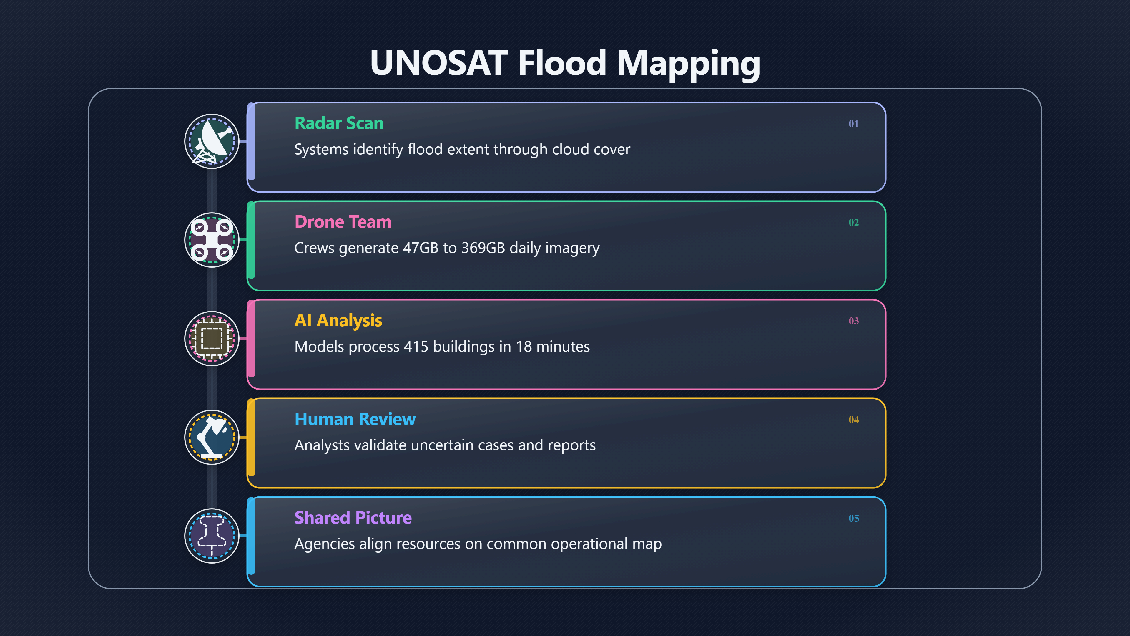
A major advantage is scale. A single disaster can produce hundreds of gigabytes of imagery in a day. Research presented at the 2026 AAAI conference described operational deployments during Hurricanes Debby and Helene in the United States. Drone teams generated between 47GB and 369GB of imagery daily, more than specialists on the ground could realistically review in time-sensitive conditions. The AI system analysed 415 buildings in roughly 18 minutes after being trained on more than 21,000 labelled post-disaster drone images. [AAAI Publications]ojs.aaai.orgAAAI PublicationsDeploying Rapid Damage Assessments from sUAS…by T Manzini · 2026 · Cited by 1 — The best performing model was deploye…
The United Nations Satellite Centre, UNOSAT, has become one of the most visible institutional users of these techniques. UNOSAT has long produced satellite-based emergency maps for humanitarian crises, but it has increasingly incorporated AI-assisted analysis to accelerate flood mapping and damage assessment. In flood operations, machine-learning systems can identify likely flood extent from radar imagery much faster than traditional manual interpretation, allowing humanitarian teams to estimate affected populations and infrastructure earlier in the response cycle. [unosat.org]unosat.orgUNOSATUNOSAT provides satellite image analysis during humanitarian emergencies related to disasters, complex emergencies and conflict sit… [UNITAR]unitar.orgUNOSAT introduces AI in its flood rapid mapping…31 Aug 2020 — By using AI, satellite based analysis and related mapping are completed…
This matters because emergency logistics are often constrained by time more than by total resources. If responders know within hours which districts suffered the heaviest destruction, they can prioritise helicopters, medical teams, fuel deliveries, or temporary bridges before conditions deteriorate further. A delayed map can mean aid arriving after preventable deaths, disease outbreaks, or mass displacement have already escalated.
AI mapping systems are especially valuable when direct access is difficult or dangerous. During conflicts or severe disasters, responders may not safely reach affected regions immediately. UN agencies used satellite analysis extensively in Gaza because on-the-ground assessment was often impossible or incomplete. Similar methods have been used after earthquakes and typhoons where roads were cut off or communications collapsed. UNITAR [United Nations University]unu.edudisaster risk reductionUnited Nations UniversityDisaster risk reduction16 Jan 2026 — Additionally, UNOSAT used GeoAI to analyse satellite imagery and create dam…
The broader coordination significance is easy to miss. These systems do not merely produce prettier maps. They create shared situational awareness. Different agencies can work from a common operational picture rather than fragmented local reports. In practice, that can reduce duplicated effort, improve routing decisions, and help governments and humanitarian organisations align scarce resources more effectively.
Why human analysts still decide what the map means
Despite the marketing language surrounding “AI disaster response”, the important decisions are still made by people. Most real deployments treat AI as a triage system rather than an autonomous authority.
This distinction matters because disaster imagery is ambiguous. A flooded field may be harmless farmland or a densely populated settlement. A collapsed roof may indicate catastrophic structural failure or only superficial visible damage. Smoke, shadows, cloud cover, and poor image resolution all complicate interpretation. Human analysts are still needed to validate findings, cross-check local reports, and decide what operational action follows.
The US Federal Emergency Management Agency (FEMA) describes its own systems in these terms. FEMA’s Response Geospatial Office uses AI and machine learning to help prioritise satellite, aerial, and radar imagery after disasters so analysts can focus attention on likely damage hotspots. The agency explicitly keeps analysts “in the loop”. [Department of Homeland Security]dhs.govDepartment of Homeland SecurityFederal Emergency Management Agency – AI Use Cases16 Dec 2024 — RGO reviews satellite, aerial, and radar i…
That human role becomes even more important because emergency aid is not simply a technical optimisation problem. Decisions involve trade-offs and public accountability. A map may indicate severe building damage in one district, but emergency managers may still prioritise another area because hospitals there are failing, evacuation routes are blocked, or vulnerable populations are concentrated nearby.
There is also a political dimension. Disaster response depends heavily on trust. Local authorities and affected communities need confidence that aid allocation is not being distorted by opaque algorithms or missing data. A system that cannot explain why it flagged one region and ignored another risks creating confusion during already chaotic conditions.
In practice, the strongest deployments combine automation with local knowledge:
- AI systems process large image datasets rapidly.
- Human geospatial analysts review uncertain cases.
- Local responders verify conditions on the ground.
- Emergency managers integrate those findings with logistics and public safety priorities.
This hybrid approach reflects a broader lesson for AI-assisted coordination. Better prediction or faster analysis does not eliminate human judgement. Instead, AI can widen the amount of information institutions can realistically process before acting.
What faster mapping changes during a real emergency
The practical value of AI disaster maps becomes clearer when looking at how emergency timelines work.
In many disasters, the first 24 to 72 hours are decisive. Search-and-rescue operations are most effective early. Hospitals need rapid supply assessments. Roads may become unusable after further flooding or landslides. Aid agencies must decide quickly where to send limited aircraft, fuel, engineers, or communications equipment.
Traditional mapping workflows can be slow because experts manually compare imagery or wait for field surveys. AI systems compress parts of that workflow from days into hours or minutes.
Several kinds of coordination improve when mapping accelerates:
Aid targeting becomes less reactive
Without a reliable operational map, agencies often distribute resources broadly and cautiously. Faster damage estimates allow more targeted deployment toward areas likely to contain concentrated need.
After major storms, for example, AI-assisted assessments can estimate which neighbourhoods suffered the highest building damage before full ground surveys are complete. That can guide where emergency shelters, water distribution points, or medical teams are established first. [AAAI Publications]ojs.aaai.orgAAAI PublicationsDeploying Rapid Damage Assessments from sUAS…by T Manzini · 2026 · Cited by 1 — The best performing model was deploye…

Remote regions become visible sooner
Satellite imagery can cover large regions quickly, including places physically inaccessible to responders. This is particularly important in mountainous terrain, island states, floodplains, or conflict zones.
UNOSAT emphasises that satellite analysis provides near real-time coverage across large areas, helping authorities identify isolated or heavily impacted communities before direct access is restored. [UNITAR]unitar.orgUNITAROCHA OPT and UNOSAT Collaborative Efforts in GazaUNOSAT's satellite imagery analysis became a crucial source of primary objective i…
Multiple agencies can coordinate from the same picture
Disaster response often involves governments, militaries, NGOs, utilities, telecom providers, hospitals, and international agencies operating simultaneously. Shared maps reduce informational fragmentation.
Even imperfect AI-generated maps can improve coordination if everyone uses the same baseline picture instead of competing assessments. In complex emergencies, common situational awareness can matter almost as much as perfect accuracy.
Long-term recovery can start earlier
Rapid assessments are not only useful for rescue operations. Governments and insurers also need damage estimates to plan rebuilding, infrastructure repair, and financial support. OECD analysis notes that machine-learning systems analysing pre- and post-disaster imagery can accelerate estimates of economic damage and infrastructure loss. [OECD]oecd.orgOECDUsing AI to measure disaster damage costs (EN)Machine-learning techniques are particularly effective in analysing satellite imagery f…
In the larger AI bloom framework, these are modest but concrete examples of machine intelligence extending institutional capacity. A society that can understand crises faster may also become more resilient to climate shocks, infrastructure failures, pandemics, or future large-scale disruptions.
Where faster damage assessment can fail in real disasters
The optimistic story has important limits. AI disaster maps can fail in ways that matter operationally and ethically.
One problem is generalisation. Systems trained on one kind of disaster or one region may perform poorly elsewhere. A flood in Bangladesh, wildfire in California, and earthquake in Türkiye create very different visual patterns. Researchers repeatedly note that models often struggle to transfer reliably across locations, weather conditions, building styles, and image qualities. [ScienceDirect]sciencedirect.comScienceDirectComputer vision tools for early post-disaster assessmentby R Soleimani · 2024 · Cited by 21 — Remote sensing data, particula…
Another challenge is data quality. Satellite imagery may arrive too late, at insufficient resolution, or obscured by clouds and smoke. Radar imagery can help in bad weather but is harder to interpret. Drone footage may be incomplete because aircraft batteries, communications, or flight permissions fail during emergencies.
False confidence is a deeper institutional risk. AI-generated maps can appear authoritative even when underlying uncertainty is high. If decision-makers trust weak outputs too heavily, resources may be diverted incorrectly. A neighbourhood incorrectly classified as lightly damaged could receive delayed assistance. A road incorrectly flagged as open could send rescue crews into dangerous conditions.
Humanitarian organisations therefore tend to frame these systems cautiously. UNOSAT’s operational dashboards explicitly note that preliminary AI analyses may not yet be validated in the field. [unosat-rm.cern.ch]unosat-rm.cern.chUNOSA T S-1 Flood AI Monitoring DashboardAll statistics are computed based on WorldPop and cover…Read more…
Bias and visibility also matter. Regions with better satellite coverage, stronger digital infrastructure, or more labelled training data may receive more accurate assessments than poorer or politically marginalised areas. That risks reinforcing global inequalities in disaster response capacity.
There are broader governance questions as well:
- Who controls the imagery and analysis systems?
- Which governments or organisations get access first?
- How transparent are the models and assumptions?
- What happens when private companies own key mapping infrastructure?
These concerns become more significant if disaster coordination increasingly depends on AI systems run by a small number of states or technology firms.

Why disaster maps matter in the larger AI coordination debate
AI disaster mapping is not evidence that AI will automatically solve coordination problems. Emergencies still expose political failures, unequal infrastructure, weak institutions, and resource shortages. Faster information does not guarantee fair or competent action.
But disaster response does show one plausible pathway by which AI could strengthen parts of civilisation’s coordination capacity. The systems work because they help institutions process complexity faster than humans alone can manage under pressure. They turn overwhelming streams of raw data into an interpretable shared picture.
That is a narrower and more credible claim than many grand predictions about AI governance. Yet it matters because modern civilisation increasingly depends on handling crises that move faster and operate at larger scales: climate disasters, infrastructure breakdowns, pandemics, refugee movements, cyberattacks, and potentially future AI-related emergencies themselves.
If advanced AI eventually contributes to a broader human flourishing story, one ingredient will likely be this kind of augmented coordination capacity: institutions that can perceive problems earlier, model consequences better, and align action more effectively across large systems.
Disaster maps are therefore less important as flashy demonstrations of AI capability than as evidence of a more practical possibility. Under the right institutional conditions, machine intelligence may help societies respond to shocks with greater speed, visibility, and collective competence rather than confusion and paralysis.
Endnotes
-
Source: sciencedirect.com
Link: https://www.sciencedirect.com/science/article/pii/S0952197624010133Source snippet
ScienceDirectComputer vision tools for early post-disaster assessmentby R Soleimani · 2024 · Cited by 21 — Remote sensing data, particula...
-
Source: unosat.org
Link: https://unosat.org/Source snippet
UNOSATUNOSAT provides satellite image analysis during humanitarian emergencies related to disasters, complex emergencies and conflict sit...
-
Source: ojs.aaai.org
Link: https://ojs.aaai.org/index.php/AAAI/article/view/41474Source snippet
AAAI PublicationsDeploying Rapid Damage Assessments from sUAS...by T Manzini · 2026 · Cited by 1 — The best performing model was deploye...
-
Source: unitar.org
Link: https://unitar.org/about/news-stories/news/unosat-introduces-ai-its-flood-rapid-mapping-operations-benefit-national-disaster-managementSource snippet
UNOSAT introduces AI in its flood rapid mapping...31 Aug 2020 — By using AI, satellite based analysis and related mapping are completed...
-
Source: unosat-rm.cern.ch
Title: UNOSA T S-1 Flood [AI Monitoring]({{ ‘ai-bloom-abun/ai-bloom-abun-98d3a6-robots-labour-66ae30-robot-dividen-ec11a5-algorithmic-m-6b5921/’ | relative_url }}) Dashboard
Link: https://unosat-rm.cern.ch/FloodAI/apps/MMR/Source snippet
All statistics are computed based on WorldPop and cover...Read more...
-
Source: unitar.org
Link: https://unitar.org/about/news-stories/stories/space-humanitarian-response-ocha-opt-and-unosat-collaborative-efforts-gazaSource snippet
UNITAROCHA OPT and UNOSAT Collaborative Efforts in GazaUNOSAT's satellite imagery analysis became a crucial source of primary objective i...
-
Source: oecd.org
Link: https://www.oecd.org/content/dam/oecd/en/publications/reports/2025/06/using-ai-to-measure-disaster-damage-costs_d551a082/b1fe3967-en.pdfSource snippet
OECDUsing AI to measure disaster damage costs (EN)Machine-learning techniques are particularly effective in analysing satellite imagery f...
-
Source: unitar.org
Link: https://unitar.org/sustainable-development-goals/united-nations-satellite-centre-UNOSATSource snippet
UNITARUnited Nations Satellite Centre UNOSATSatellite imagery analysis can cover large areas and provide accurate information in near rea...
-
Source: ojs.aaai.org
Link: https://ojs.aaai.org/index.php/AAAI/article/view/41474/45435Source snippet
AI/ML system during the 2025 Atlantic Hurricane Season. Deployment at Hurricanes Debby & Helene.Read more...
-
Source: ojs.aaai.org
Link: https://ojs.aaai.org/index.php/AAAI/article/view/41248/45209Source snippet
Benchmark Dataset for Spatially Aligned Road Damage...by T Manzini · 2026 — disaster response, evaluating and validating one baseline mo...
-
Source: unosat.org
Link: https://unosat.org/products/Source snippet
Madagascar. Preliminary satellite-derived damage assessment in Boeny Region, Madagascar as of 1 February 2026. SEE MORE.Read more...
Published: February 2026
-
Source: dhs.gov
Link: https://www.dhs.gov/ai/use-case-inventory/femaSource snippet
Department of Homeland SecurityFederal Emergency Management Agency – AI Use Cases16 Dec 2024 — RGO reviews satellite, aerial, and radar i...
-
Source: unu.edu
Title: disaster risk reduction
Link: https://unu.edu/cpr/report/disaster-risk-reductionSource snippet
United Nations UniversityDisaster risk reduction16 Jan 2026 — Additionally, UNOSAT used GeoAI to analyse satellite imagery and create dam...
-
Source: frontiersin.org
Link: https://www.frontiersin.org/journals/environmental-science/articles/10.3389/fenvs.2022.969758/fullSource snippet
Disaster assessment using computer vision and satellite...by D Kim · 2022 · Cited by 25 — We propose a novel deep-learning-based solutio...
Additional References
-
Source: researchgate.net
Link: https://www.researchgate.net/figure/Example-of-a-sUAS-used-in-response-to-Hurricane-Helene_fig1_392918016Source snippet
Example of a sUAS used in response to Hurricane Helene.This paper details four principal challenges encountered with machine learning (ML...
-
Source: unglobalpulse.org
Link: https://www.unglobalpulse.org/project/pulsesatellite-using-human-ai-collaborations-to-analyse-satellite-imagery-in-disasters/Source snippet
PulseSatellite: Using Human-AI Collaborations to Analyse...PulseSatellite allows our UN colleagues to get the most out of earth imagery...
-
Source: un.org
Link: https://www.un.org/technologybank/un-technology-bank-and-unitar-unosat-enhance-geospatial-technologies-disaster-managementSource snippet
satellite imagery with a specific focus on disaster risk management. The newly developed tool by UNITAR use artificial intelligence (AI)...
-
Source: fygurs.com
Title: Satellite Imagery Disaster Damage Assessment, AI Use Case What it is
Link: https://www.fygurs.com/use-cases/satellite-imagery-disaster-damage-assessmentSource snippet
Computer vision models analyze pre- and post-disaster satellite imagery to automatically detect and classify structural damage, flooded a...
-
Source: stories.tamu.edu
Title: ai turns drone footage into disaster response maps in minutes
Link: https://stories.tamu.edu/news/2025/07/28/ai-turns-drone-footage-into-disaster-response-maps-in-minutes/Source snippet
Turns Drone Footage Into Disaster Response Maps In...28 Jul 2025 — A system developed at Texas A&M uses [drone imagery]({{ 'ai-bloom-abun/ai-bloom-abun-98d3a6-ai-coordinati-e1e5d8-ai-disaster-m-584aa7-hurricane-dro-75c4e2/' | r...
-
Source: en.reset.org
Title: unosat using satellites map future humanitarian aid 11252020
Link: https://en.reset.org/unosat-using-satellites-map-future-humanitarian-aid-11252020/Source snippet
reset.orgUNOSAT: Using Satellites to Map the Future...Nov 30, 2020 — UNOSAT translates satellite data into information-rich maps and rep...
-
Source: dronelife.com
Title: drone disaster response magic box for emergency management
Link: https://dronelife.com/2025/09/05/drone-disaster-response-magic-box-for-emergency-management/Source snippet
Drone Disaster Response Project CLARKE5 Sept 2025 — A software package that uses artificial intelligence (AI) and machine learning to hel...
-
Source: reliefweb.int
Link: https://reliefweb.int/report/world/ai-google-research-and-un-boosts-humanitarian-disaster-response-wider-coverage-faster-damage-assessmentsSource snippet
The solution works on damages from earthquakes, storms, fires, as well as floods.Read more...
-
Source: developer.nvidia.com
Title: ai helps detect disaster damage from satellite imagery
Link: https://developer.nvidia.com/blog/ai-helps-detect-disaster-damage-from-satellite-imagery/Source snippet
Helps Detect Disaster Damage From Satellite Imagery12 Dec 2018 — Researchers from Facebook and CrowdAI developed a deep learning-based al...
-
Source: techbriefs.com
Title: 53810 ai powered action for rapid disaster response
Link: https://www.techbriefs.com/component/content/article/53810-ai-powered-action-for-rapid-disaster-responseSource snippet
AI-Powered Action for Rapid Disaster Response10 Sept 2025 — A system uses drone imagery and artificial intelligence to rapidly assess dam...
Amazon book picks
Further Reading
Books and field guides related to AI disaster maps. Use these as the next step if you want deeper reading beyond the article.
Artificial intelligence
First published 1994. Subjects: problem solving, constraint satisfaction, knowledge, reasoning, planning.

Artificial Intelligence and Soft Computing
First published 2012. Subjects: Computer Imaging, Vision, Pattern Recognition and Graphics, Database management, Information storage and...
Disaster response and recovery
First published 2007. Subjects: Disaster relief, SOCIAL SCIENCE / Sociology / General, Emergency management.
Case Studies In Disaster Response And Emergency Management
First published 2013. Subjects: Emergency management, Case studies, POLITICAL SCIENCE / Public Policy / City Planning & Urban Development...
eBay marketplace picks
Marketplace Samples
Example marketplace items related to this page. Use the search link to explore similar finds on eBay.
Example eBay listing
Artificial intelligence Framed Wall Art Poster Canvas Print Picture
USD 12.04 | GB

Example eBay listing
A.I. Artificial Intelligence Movie Poster Print, Wall Art - Unframed
USD 19.95 | Free shipping | US

Example eBay listing
Artificial Intelligence AI Framed Wall Art Poster Canvas Print Picture
USD 12.04 | GB
Example eBay listing
A.I. Artificial Intelligence (2001) Movie Poster Wall Art Print
USD 48.02 | Shipping USD 21.32 | AU

Example eBay listing
A.I. Artificial Intelligence Movie Film Poster Art Print
GBP 4.99 | Free shipping | GB

Example eBay listing
A I Artificial Intelligence 6 Movie Poster Art Print Print Classic Rare Gallery
GBP 49.00 | Free shipping | GB

Example eBay listing
AI - Artificial Intelligence (Poster + Slipcase) Blu-Ray
GBP 10.49 | Free shipping | GB

Example eBay listing
A. I. Artificial Intelligence. Jude Law. Original UK Video Poster.
GBP 8.11 | Shipping GBP 3.38 | GB
Topic Tree